If you’re like most people, you enjoy turning on the faucet whenever you want and having water come out. But you’re also aware that every once in a while (hopefully not too much more) no water comes out, or worse, the water that does come out looks alarmingly undrinkable. In many cities, pipes are old and leaks are common; today, data science — more specifically predictive maintenance techniques — can help.

Dataiku’s new partnership with Esri France — the pioneer and world leader in geographic information systems (GIS) — allows businesses around the world to bring data science to the most analog environments, addressing issues such as water leaks and quality (the example we'll walk through here) by approximating the data that would normally come from sensors. Going forward, Esri and Dataiku users can leverage the combination of Esri’s platform along with Dataiku’s end-to-end data science platform to address real-world issues.
In this blog post, see how the teams at Esri and Dataiku were able to use these two technologies to build a model to predict water leaks without any sensors anywhere in the system.
How We Made a Smart Network in an Analog Environment
Water systems are some of the oldest networks still working today, yet they are one of the systems we rely on the most in day-to-day life. In many places, the pipes are many dozens of years old, and keeping the whole system running is a major challenge for the utility company managing it. Even though water utilities have been working hard to upgrade these networks, there are often large swaths that remain classical, non-smart, networks.
In order to build a predictive maintenance engine without any of the Internet of Things (IoT) data that these models tend to rely on, we used:
- Records of previous water leak locations.
- Information about the systems themselves, such as pipe length and material type.
- ArcGIS, Esri’s flagship GIS, which allows for the rendering and analysis of geospatial data — that is, map data in 3D (this was one of the key drivers of the richness of the model that we developed).
Esri ArcGIS Dashboard developed with Webapp Builder to give insights to maintenance crew on-the-ground.
Of course, one of the cornerstones of the project was the fact that any insights we were able to provide via a predictive maintenance model would not be worth anything if they couldn’t be accessed by experts in the field.
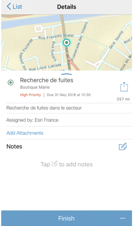
So we used the Workforce For ArcGIS component to automatically help field workers prioritize maintenance scheduling and inspections based on predicted risks. These workers then enter the locations where real leaks were discovered, and this data can be used to create a feedback loop to improve the performance of the model.

Workforce for ArcGIS, for scheduling maintenance operations and communicating with the field.
Unlocking Insights With Geospatial Data
The key to the Dataiku-Esri integration is bringing the power of geospatial data to a machine learning platform designed to plug in easily to any organization’s infrastructure, unlocking insights and value. The example described above is just one potential application of this combination — machine learning with geospatial data could be applied to all sorts of challenges.
Technically, the integration allows Dataiku to:
- Connect Esri’s database schemas and to connect the ArcGIS Enterprise Big Data Store through Python and REST.
- Provide access to ArcGIS enterprise functions in Dataiku Jupyter notebooks.
- Add new rich features derived from rich GIS to machine learning projects.
If you’re a business that leverages GIS, you can leverage this powerful combination of the “science of where” and machine learning at scale — get started on the Esri platform.


