


Here’s how to create an interactive map with Web AppBuilde for ArcGIS using ESRI and Dataiku, which will reveal the different levels of predicted and real crimes in different areas of Greater London in just a click.
Predict Crime in London with Machine Learning
If you read my last blog post, you’ll know that I used Dataiku to build and train a model that would predict the number of crimes in the Greater London area between January and August 2016. We can take the LSOA of Westminster as an example of the model’s accuracy:
 3 225,3704 crimes predicted (“sum prediction”) versus 3 365,0000 observed (“sum target_nb_cime”)
The model therefore worked very well at predicting the number of crimes in different areas of London and was able to show us which areas were likely to have the highest levels of crime. It was interesting to note that closeness to the city center, such as in areas like Westminster, generally indicated higher levels of crime.
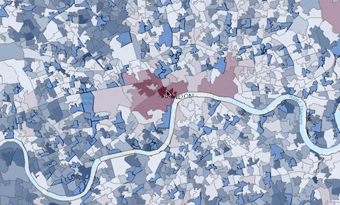
Creating a Map with This Data
As you can see from the above screenshot, I was able to use my model to then create an interactive map of London that reveals data relating to levels of crime in different areas of the city. If you want to know about what these different figures relate to, remember to look back on my last post which provides a step-by-step guide on how I built the predictive models in Dataiku.
How Does this Project Differ from Previous Work on Crime Prediction?
The focus of this project was on developing data products that leveraged open source data, hence why I used the open source crime database on the UK police portal. The project was built on a simple approach and for the purpose of using data that is readily available.
Rather than specifically highlighting how predictive models can solve crime, I wanted to demonstrate what we can do with data when it is available in this way. More broadly, the project shows what could be possible if a governments or councils were to develop a similar approach.
What’s more, using Dataiku, I was able to apply an end-to-end approach to using this data and building my models. Even when using Esri (Dataiku is a silver partner) to create the interactive map in just a few clicks, I was able to easily embed this into my project with the Dataiku web app capabilities based on Esri Arcgis online resources.